|
| |
Remote sensing
Main |
3D
Page |
I-drop
blocks |
Discussions
|
Free
3D textures |
Free
AutoCAD Blocks |
CAD-Magazines |CAD Resources
User Group
|
Acad-Commands
|
CAD Training
| 3D Max Resources
|
3D Perspectives |
Building Plans |
GIS
|
Links
Remote sensing |
Multimedia, Animation, Video, games,
CAD, 3 dimension Links,
AutoLISP
New
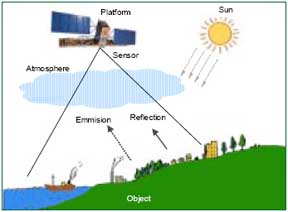
1. What is remote sensing?
Remote sensing is the science and art of obtaining useful information about
an object, area or phenomenon through the analysis of data acquired by a
device that is not in contact with the object, area, or phenomenon under
investigation.
2. What instruments are used to collect Earth
science data remotely?
Aircraft: Airplanes have been used
since the 1930s to carry cameras and sensors to study the earth. Airplanes
may carry cameras to collect images of a part of the earth's surface. The
final aerial photograph usually consists of a series of overlapping vertical
photos taken in strips that form the basis for mapping. Airplanes are also
used to carry sensors. For example, the United States Geological Survey (USGS)
uses Side-Looking Airborne Radar (SLAR) instrument for various projects in
the United States to map geologic features, explore for mineral and energy
reserves, and identify potential environmental hazards. The United States
also flies a Light Detection and Ranging (LIDAR) instrument aboard aircraft.
Spacecraft: Satellites are also used to collect images and data about
the earth. The Earth observing satellites, as they are referred to, carry
sensors which are capable of recording wavelengths across the range of the
electromagnetic spectrum, from infrared to visible radiation. Some
satellites carry sensors that collect data passively, by recording radiation
that is being radiated or reflected off the Earth's surface or atmosphere.
Other satellites collect data actively, by emitting radiation and then
recording what is reflected back from the Earth's surface or atmosphere.
3. How do passive satellite sensors collect
data?
A typical image derived from an infrared passive sensor consists of small equal
areas referred to as picture elements, or 'pixels,' arranged in regular rows and
columns. Each pixel has a numerical value called a digital number (DN) that
records the intensity of electromagnetic energy measured for the area of ground
represented by the pixel. The DN range from 0 to some higher number on a
gray-scale. Each pixel is also give x and y coordinates to place
it. The image can therefore be described in strictly numeric terms on a
three-coordinate system with x and y locating the pixel and z
giving the DN displayed as a gray scale intensity value.
4. How are passive satellite sensors defined?
Passive sensors are defined in terms of their spatial, spectral, and temporal
resolutions.
5. What do the terms "spectral resolution,"
"spatial resolution," and "temporal resolution" mean?
Spatial Resolution: The spatial
resolution of a sensor is the smallest area that is recorded as a separate
unit (pixel). For instance, one meter spatial resolution means that one
pixel of a digital image represents an area on the Earth's surface measuring
one meter in length by one meter in width. See the Answer to
Question 9 also.
Spectral Resolution: Spectral resolution refers to the number and
dimension of bands (or wavelengths) of the electromagnetic spectrum that a
sensor records. The higher the number of bands, the greater the sensor's
ability to distinguish between objects.
Temporal Resolution: Temporal resolution, also known as repeat time,
is the frequency with which a sensor passes over the same area.
6. What are examples of satellites that carry
passive sensors?
Satellites carrying passive sensors include: NASA satellites
Landsat and
Terra; NOAA's Polar Orbiting
Environmental Satellites (POES); the OrbView-2 satellite carrying the
SeaWiFS
sensor jointly operated by NASA and ORBIMAGE;
Space Imaging's IKONOS
satellite; and France's
Systeme Pour L' Observation de la Terre (SPOT) satellites.
7. How do active sensors on satellite collect
data?
Active remote sensing devices, on the other hand, emit high-energy
electromagnetic radiation and record the relative amount and pattern of the
energy that is reflected back. Many of these devices operate at wavelengths that
not only penetrate cloud cover, but also penetrate below the surfaces of water
bodies, forest canopies, and the ground to generate additional data. The
trade-off for enhanced imaging capabilities, however, is an increased complexity
of data interpretation.
( Courtesy:
http://www.earthpace.com/resources/nepa/srs_as.html )
Articles
More...
| |
|